Salgotarjan
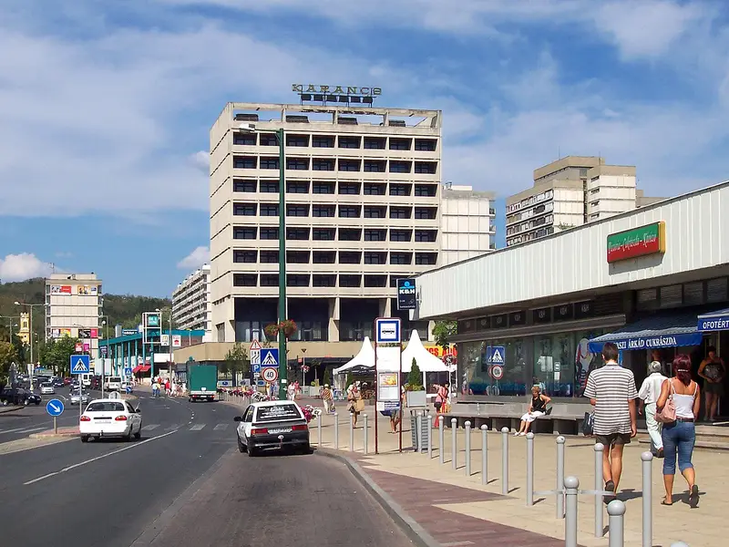

Reaching Salgotarjan from London emits 43.5 kg CO₂e return by rail (21h 24m each way) against 371 kg by air — 9× the carbon. It averages 22.8 °C in August and 1.1 °C in December.
Salgótarján is the county seat and largest city in Nógrád county, Hungary. — Wikivoyage, CC BY-SA 4.0
When to go: Salgotarjan is warmest in August (22.8 °C), sunniest in July (13.3 h a day); coldest in December (1.1 °C). Month by month
Getting there
| From | Distance | By rail | Rail time | By air | Air time |
|---|---|---|---|---|---|
| Amsterdam | 1,160 km | 34.2 kg | 18h | 292 kg | 5h |
| Barcelona | 1,575 km | 46.5 kg | 24h 24m | 396 kg | 5h 36m |
| Berlin | 669 km | 19.7 kg | 11h 42m | 168 kg | 4h 24m |
| Birmingham | 1,610 km | 56.6 kg | 24h 12m | 405 kg | 5h 36m |
| Bristol | 1,644 km | 57.3 kg | 24h 24m | 414 kg | 5h 42m |
| Brussels | 1,155 km | 34.1 kg | 17h 48m | 291 kg | 5h |
| Cardiff | 1,685 km | 60.5 kg | 24h 42m | 424 kg | 5h 42m |
| Copenhagen | 977 km | 28.8 kg | 16h 6m | 246 kg | 4h 48m |
| Dublin | 1,912 km | — | — | 481 kg | 6h |
| Edinburgh | 1,788 km | 86.4 kg | 27h 12m | 450 kg | 5h 54m |
| Frankfurt | 839 km | 24.8 kg | 14h 6m | 211 kg | 4h 36m |
| Glasgow | 1,847 km | 88.2 kg | 27h 18m | 465 kg | 6h |
| Leeds | 1,616 km | 65.4 kg | 25h | 407 kg | 5h 42m |
| Lisbon | 2,541 km | 75.0 kg | 38h 42m | 639 kg | 6h 54m |
| Liverpool | 1,699 km | 66.5 kg | 25h | 427 kg | 5h 48m |
| London | 1,474 km | 43.5 kg | 21h 24m | 371 kg | 5h 30m |
| Madrid | 2,047 km | 60.4 kg | 27h 54m | 515 kg | 6h 12m |
| Manchester | 1,653 km | 64.6 kg | 24h 54m | 416 kg | 5h 42m |
| Milan | 859 km | 25.3 kg | 14h 6m | 216 kg | 4h 36m |
| Munich | 610 km | 18.0 kg | 10h 18m | 154 kg | 4h 18m |
| Newcastle | 1,658 km | 75.5 kg | 25h 42m | 417 kg | 5h 42m |
| Nottingham | 1,570 km | 57.6 kg | 24h 30m | 395 kg | 5h 36m |
| Oslo | 1,438 km | 42.4 kg | 22h 48m | 362 kg | 5h 24m |
| Paris | 1,287 km | 38.0 kg | 17h 6m | 324 kg | 5h 12m |
| Prague | 450 km | 13.3 kg | 8h 30m | 113 kg | 4h 6m |
| Rome | 896 km | 26.5 kg | 14h 54m | 226 kg | 4h 42m |
| Sheffield | 1,600 km | 61.8 kg | 24h 48m | 403 kg | 5h 36m |
| Southampton | 1,557 km | 52.5 kg | 24h 6m | 392 kg | 5h 36m |
| Stockholm | 1,254 km | 37.0 kg | 20h 6m | 315 kg | 5h 12m |
| Vienna | 255 km | 7.5 kg | 5h 42m | 64.1 kg | 3h 48m |
| Warsaw | 467 km | 13.8 kg | 8h 6m | 118 kg | 4h 6m |
| Zurich | 845 km | 24.9 kg | 14h 12m | 213 kg | 4h 36m |
The year in Salgotarjan
| Jan | Feb | Mar | Apr | May | Jun | Jul | Aug | Sep | Oct | Nov | Dec | |
|---|---|---|---|---|---|---|---|---|---|---|---|---|
| Temp °C | 1.5 | 4.4 | 7.1 | 10.5 | 15.7 | 19.5 | 22.6 | 22.8 | 18.4 | 11.8 | 3.5 | 1.1 |
| Sun h/day | 4.6 | 6.6 | 8.3 | 9.7 | 11.4 | 11.9 | 13.3 | 12.2 | 9.5 | 7.6 | 5.3 | 3.6 |
| Rain mm/day | 2.2 | 1.0 | 1.6 | 2.1 | 3.0 | 4.0 | 1.4 | 2.1 | 3.0 | 2.5 | 2.5 | 1.8 |
When to go
Salgotarjan is warmest in August at 22.8 °C but brightest in July, averaging 13.3 hours of sun a day — the two do not always coincide, which is worth knowing before booking. Its coldest is December at 1.1 °C.
Three months worth booking
The same year of measurements, decided rather than tabulated. Each opens the map below on dates in that month.
How busy it gets
Nógrád records 0.8 overnight stays per resident a year (145,689 nights in 2025). Comparatively quiet by European standards.
Eurostat, nights spent at tourist accommodation by NUTS 3 region, against resident population. Shown for context only — it plays no part in which destinations appear or in what order. Eurostat does not cover the United Kingdom after 2016, nor North Africa or the Levant at all, so this figure is absent for roughly a third of the destinations here.
Where to stay in Salgotarjan
Places to stay in Salgotarjan, Hungary, on a live map. Prices and availability come from Stay22 and its booking partners.
Search places to stay in Salgotarjan →Opens the booking search in a new tab. Same partners as the map below.
Affiliate disclosure. A booking made through this map may earn 0xCarbon a commission, at no extra cost to you. It changes nothing above it: the emissions figures come from UK Government conversion factors and are computed before anyone is paid anything.See the method.
Distances are great-circle. Rail assumes international rail at 0.01135 kg CO₂e per passenger-km with a 1.3× track detour allowance; flights use 0.12576 kg per passenger-km including radiative forcing. Journey times are modelled, not timetabled. Full method.